
Weather Around The World, 6/7/16: The World Warms; Paris Floods; Eagles And El Niño Die; Airliner Crashes; Tropics Come Alive

Tropical Storm Colin, the earliest C-named storm, was near the Georgia coast on June 7. It will spin harmlessly out to sea. Graphic courtesy of National Hurricane Center.
May was another record-breaker for global temperatures, despite the fading El Niño. There was flooding in Europe and the US. Hurricane season has started with a bang. And birds are in trouble. No telling what’s ahead — but we’ll try.
April Global Temperatures
No summary of May weather would be complete without mention of the NOAA report on global land and sea temperatures for April, which was published on May 18.
The recent spike in temperatures is nothing short of astounding. Hopefully it is that — a spike caused by El Niño. Even if it is, the change in temperature from the last strong El Niño (1997-98), which also produced a spike, is rather dramatic — a rate of 2.5°C (4.5°F) per century.
With El Niño rapidly morphing into La Niña, climatologists hold out hope for a temporary leveling off of global temperatures while the signatories to the recent Paris climate agreement formulate and then begin to implement ways to reduce carbon dioxide emissions. In view of the most recent data, it might be a good idea if the word ‘urgent’ entered the discussion.
El Niño Is Dead; Long Live La Niña
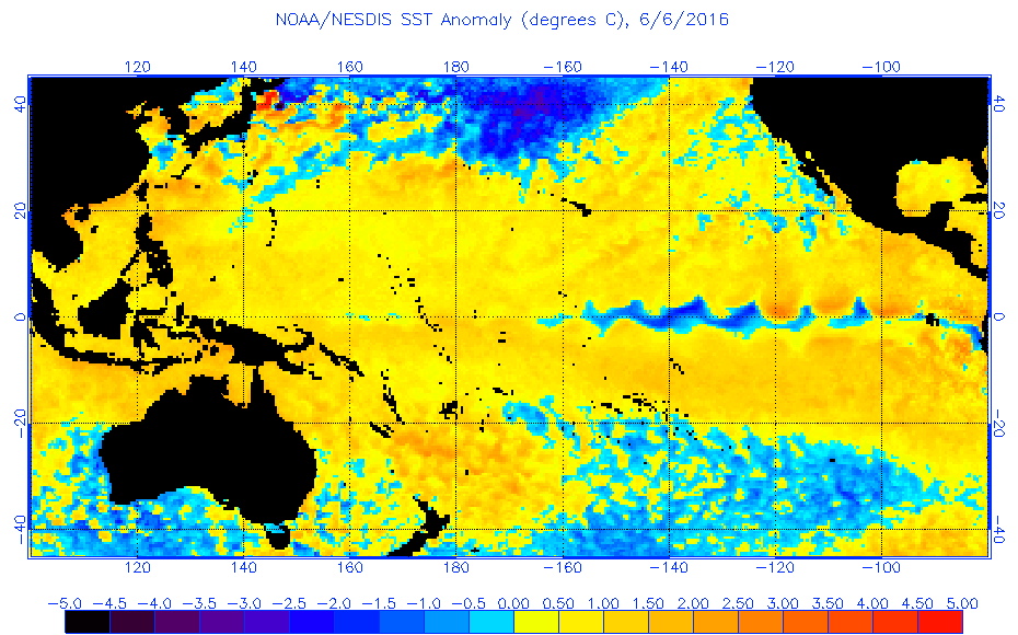
Cold water has replaced warm in the equatorial Pacific Ocean. El Niño has ended. Graphic courtesy of NOAA.
El Niño is over, though it will be a couple of months before NOAA officially declares it so. That is because their definition involves a specific spot in the middle of the Pacific Ocean, and encompasses overlapping three-month periods.
A look at the most recent sea surface temperatures tells us that as a practical matter, this El Niño is finished.
Powerful El Niños are often followed by powerful and long-lasting La Niñas. The El Niño of 1997-98 was followed by just a single month of officially neutral conditions, succeeded by a La Niña that lasted three years.
What is likely to happen if this El Niño is followed by a strong La Niña?
During the record La Niña of 1998, Atlantic hurricane activity was far above normal, and hurricanes that summer killed more people than in any other year. Just sayin’.

Eastern Australia tends to be dry during El Niño and wet during La Niña. Graphic courtesy of Australia Bureau of Meteorology.
Australia is the closest large land mass to the equatorial Central Pacific Ocean, so it is significantly affected by El Niño. Eastern Australia tends to be dry during El Niño and wet during La Niña.
Floods Claim Lives In Europe And US
Serious flooding events have taken place in the last couple of weeks in Europe and the southern US. Are they connected?
The answer is an emphatic, ‘probably.’
The jet stream circles the globe in mid-latitudes, dipping here and there as waves ripple through. Occasionally the pattern becomes amplified enough for it to break down into swirls. An amplified jet stream pattern is called an omega block because of its shape like the Greek letter. Ω
When this happens, movement slows or stops. Whereas the normal jet stream moves rain systems along, the omega block can keep them in place for many days.
Clogging of the jet stream in one place can create blocks up and down the line. The start of the process is like the chicken and the egg, but the fact that major flooding occurred in two places at the same time is probably not a coincidence.
Qualitatively, the atmosphere appears to favor blocking patterns more than it used to. There is a suspicion that this change has something to do with global warming, but this conclusion awaits careful study and quantitative evidence.
Conservation Isn’t Easy: Spitting Into The Wind
For every two steps the world takes in combating global warming, it seems there’s at least a step back somewhere. Wind power is a good example.
What could be better than harnessing the wind, which blows with considerable regularity and the source of which is the virtually infinite power of the sun? Well, actually, what could be better is a source of energy that doesn’t kill birds. So far no one has developed a more efficient way to harness the power of the wind than by windmills. And it turns out that the whirling blades of windmills are killing hundreds of thousands of birds (and nearly a million bats) each year.
The Obama Administration has recently issued new rules regarding the killing of eagles by wind turbines: 4200 bald eagle deaths are allowed per year. At Decoded Science, we like the idea of replacing fossil fuels with wind as a source of power — but we also like eagles. Maybe Bill Maher’s quip was more than just funny: If God wanted us to use the sun for power, he wouldn’t have put it 93 million miles away.
Red Knots Affected By Climate Change
On the subject of man’s effect on birds, another species is in trouble. This one is suffering because warming of the Arctic has changed the timing of insect reproduction.
The red knot is a hemisphere-exploring bird that winters in the tropics and breeds in the Arctic. A new study, published in the journal Science, has found that the birds are in serious decline. The reason seems to be that the breeding season, which has historically coincided with insect hatches, a rich source of food, has now become partly decoupled from the hatches due to global warming. The insects hatch about two weeks earlier while the red knots keep to their historical timetable. As a result, the fledgling birds are undernourished for their nine thousand mile flight to wintering grounds. Their numbers are falling, their average weight is down, and the surviving birds are judged generally less fit.
Climate Refugees In Louisiana
The United States is a desirable destination for refugees, not a country that normally produces them; yet a coastal Louisiana community has been officially granted status as a source of climate refugees. To be fair, the cause of the problem isn’t entirely the burning of fossil fuels, which warms the planet causing the oceans to rise. A second factor is the extraction of those fossil fuels from beneath the surface of Louisiana, causing the ground to sink. Both effects should make us think about how we meddle with the environment.
In any event, the Department of Housing and Urban Development has issued a grant of $48 million to relocate residents of Isle de Jean Charles, most of whom are Native Americans of the Biloxi-Chitimacha-Choctaw tribe, which has occupied the land for generations.
Weather And EgyptAir 804
Weather is often a factor in one way or another when an airliner crashes: sometimes the weather causes the crash; sometimes it hampers the search for wreckage.
It was easy to rule out weather as a possible cause of the recent EgyptAir crash in the Mediterranean Sea. The weather was as tranquil as it gets, both at the ground and at the 37,000 foot flight level. Some stormy weather moved in after the crash, but was only a minor nuisance in the search for debris and victims.
Hurricane Season Begins
The ‘official’ start of hurricane season is May 15, 2016 in the eastern Pacific, and June 1, 2016 in the Atlantic. These dates mean nothing; there have been hurricanes in every month. However, strong hurricanes are restricted to the warm water months — July through October, and that’s stretching it a bit.
Apparently Mother Nature is paying attention to the ‘official’ hurricane season. She spawned a minimal tropical storm near the east coast of the US in late May and a more substantial system, Tropical Storm Colin, in the Gulf of Mexico over the weekend of June 5. This is the earliest the C-named storm has ever formed in the Atlantic, but the record has to come with an asterisk. Alice was an early-January hurricane in the far eastern Atlantic that was a leftover from 2015, and it was probably more subtropical than tropical. And Bonnie, the May storm, barely reached tropical storm strength and in the days before satellite measurements of wind almost certainly would not have been named.
In the Pacific, a suspicious area in the typical breeding ground south of Mexico last week fizzled out as it drifted west. Water temperatures in the Pacific between North America and Hawaii are a little cooler than they were last year, so perhaps we won’t see a repeat of the record-breaking number of hurricanes that threatened the island chain last summer.
But never mind the official seasons, or the individual factors that can affect the overall numbers of hurricanes. If you live in a place where a hurricane has ever struck, be ready.
Warm Bay Of Bengal Spawns A Tropical Cyclone

Tropical cyclone Roanu wasn’t very strong. There may be more cyclones this summer in the warm Indian Ocean. Graphic courtesy of US Navy.
Decoded Science has repeatedly pointed out the anomalously warm water in the Indian Ocean.
The combination of warm water in the Bay of Bengal and the monsoon front produced conditions favorable to tropical cyclone formation in mid-May.
Tropical Cyclone Roanu never reached hurricane strength as it paralleled the coast, but it caused over 90 deaths in Sri Lanka and Bangladesh, and may be a portent of summer activity in these very warm waters.
Weather circulations in one place can affect the weather in others. Roanu’s circulation was strong enough to bring hot dry air southward behind it. Many Indian cities set records for the date and the month, but the temperature winner was Phalodi in the state of Rajasthan, where the temperature rose to 124° Fahrenheit on May 19, an all-time high for the country of India.
What’s In Store For The Rest Of June?
It’s an exciting time for weather nuts. El Niño is gone, but will La Niña follow? And if so, will that produce an active Atlantic hurricane season? Will May global temperatures continue their recent eyebrow-raising rise (NOAA will release the data on June 15)?
The recent tendency of the jet stream to get stuck in an omega block increases the likelihood of prolonged heat waves — and floods.
Tell Decoded Science what you see where you live.
© Copyright 2016 Jon Plotkin, All rights Reserved. Written For: Decoded Science
Categories: Hurricane